Navigating Bengaluru's bustling streets becomes seamless with the Bangalore Metro Route Map. This comprehensive guide offers insights into the city's rapid transit system, ensuring commuters experience efficient and stress-free journeys.
Bangalore Metro: Enhancing Urban Mobility
Since its inception in 2011, the Bangalore Metro, popularly known as Namma Metro, has transformed the city's transportation landscape. By connecting key residential, commercial, and industrial zones, it addresses the challenges of urban congestion and promotes sustainable travel.
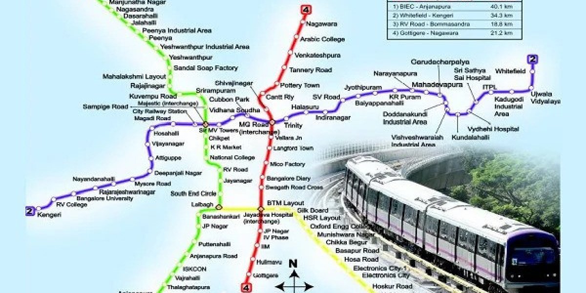
Purple Line: East-West Connectivity
The Purple Line stretches from Challaghatta in the southwest to Whitefield (Kadugodi) in the east, covering approximately 37 kilometers. This line serves vital areas, including MG Road, Vidhana Soudha, and Baiyappanahalli, facilitating smooth commutes across the city.
Green Line: North-South Corridor
Spanning about 32 kilometers, the Green Line connects Silk Institute in the south to Madavara in the northwest. It traverses significant locales such as Yeshwanthpur, Majestic, and Jayanagar, enhancing accessibility for daily commuters.
Upcoming Lines: Expanding the Network
The Bangalore Metro continues to evolve with several lines under construction:
Yellow Line: Linking Rashtreeya Vidyalaya Road to Bommasandra, this 16-kilometer stretch aims to serve the southern tech corridors.
Pink Line: Connecting Kalena Agrahara to Nagawara over 18 kilometers, it will intersect with other lines, boosting network integration.
Blue Line: Extending from Kasturi Nagar to Kempegowda International Airport, this 29-kilometer line will offer direct airport access.
Station Highlights
With 68 operational stations, the metro system ensures comprehensive coverage:
Purple Line Stations: Key stations include MG Road, Indiranagar, and Whitefield, serving commercial and residential hubs.
Green Line Stations: Notable stops like Yeshwanthpur and Jayanagar cater to both industrial and residential areas.
Operational Timings
The metro operates daily, accommodating various schedules:
Weekdays: Services run from early morning to late evening, with trains every few minutes during peak hours.
Weekends: Operations commence a bit later in the morning, maintaining consistent frequency to serve weekend travelers.
Interchange Stations: Key Transition Points
Interchange stations make commuting across different lines smoother. Majestic (Nadaprabhu Kempegowda Station) is the most crucial junction, allowing commuters to switch between the Purple and Green Lines. Additional interchange stations will become functional with the opening of new lines, including Jayadeva Hospital, which will link the Yellow and Pink Lines.
Accessibility Features in Metro Stations
Bangalore Metro ensures comfort for all passengers, including those with mobility challenges. Most stations include elevators, escalators, tactile flooring, and wheelchair-friendly pathways. Announcements in both English and Kannada help commuters understand the station details clearly.
Impact on Real Estate and Local Economy
The expansion of the metro network boosts real estate development around metro stations. Residential and commercial projects see increased demand due to enhanced connectivity. Retail establishments near metro corridors report a rise in footfall, benefiting the local economy.
Environmental Benefits of the Metro System
Metro trains contribute to reducing vehicular traffic, cutting down carbon emissions, and promoting eco-friendly travel. Fewer private vehicles on roads lead to improved air quality, noise reduction, and energy conservation across Bengaluru.
Integration with Other Transport Modes
Namma Metro integrates with bus services operated by BMTC, creating a unified transit experience. Several metro stations have adjoining bus terminals and dedicated pickup/drop points for autos and cabs. This multi-modal setup ensures hassle-free last-mile connectivity.
Safety and Security Measures
The metro prioritizes commuter safety with measures such as CCTV surveillance, security personnel, and baggage scanners at every station. Emergency buttons and intercom systems inside the trains add an extra layer of security.
Smart Card and Ticketing Convenience
Smart cards and QR code-based mobile tickets make travel convenient. Commuters top up their cards at stations or online and enjoy contactless entry through automated gates. Ticket vending machines reduce wait times and enhance user experience.
Metro’s Role in Reducing Traffic Congestion
The Bangalore Metro plays a major role in easing road traffic. By attracting daily office-goers and students, it reduces dependency on personal vehicles. Areas with metro access see faster travel times and fewer traffic bottlenecks.
Tourist-Friendly Travel with Metro
Tourists exploring Bengaluru can conveniently access landmarks such as Cubbon Park, Lalbagh, and Bangalore Palace via metro. With clear route maps, English signage, and station help desks, navigating the metro becomes simple for visitors.
Future Developments
The Bangalore Metro's expansion plans include Phase 3, introducing new corridors and enhancing connectivity. These developments aim to further integrate the metro with other transport modes, promoting a cohesive urban transit system.
Conclusion
The Bangalore Metro Route Map stands as a testament to the city's commitment to efficient and sustainable transportation. By continuously expanding and upgrading, it ensures that Bengaluru's residents and visitors can navigate the city with ease and confidence.
For more information or assistance, feel free to contact us.
Frequently Asked Questions
1. How many lines does the Bangalore Metro currently operate?
Currently, the Bangalore Metro operates two main lines: the Purple Line and the Green Line. Additional lines are under development.
2. What are the operational hours of the Bangalore Metro?
The metro operates daily from early morning to late evening, with slight variations between weekdays and weekends.
3. Which is the main interchange station in the Bangalore Metro?
Majestic (Nadaprabhu Kempegowda Station) serves as the primary interchange between the Purple and Green Lines.
4. Are there facilities for differently-abled passengers at metro stations?
Yes, most stations include ramps, elevators, tactile paths, and other features for accessibility.
5. Is the Bangalore Metro connected to the airport?
Currently, the metro is not directly connected to the airport. However, the upcoming Blue Line will link the city to Kempegowda International Airport.
6. Can I use a smart card for travel?
Yes, smart cards are available for regular commuters, allowing contactless travel and easy top-up options.
7. How frequent are the trains during peak hours?
Trains run at short intervals during peak times to manage high commuter volume.
8. Does the Bangalore Metro support QR code-based tickets?
Yes, mobile QR code tickets are accepted and can be scanned at entry and exit gates.
9. Are metro stations equipped with security systems?
All stations have security personnel, surveillance cameras, and baggage scanners to ensure commuter safety.
10. Will new metro lines intersect with existing ones?
Yes, upcoming lines like the Pink, Yellow, and Blue will intersect with current routes at planned interchange stations, enabling seamless travel.